
Nocturnal images of the Earth from Space
 This image of Earth’s city lights was created with data from the Defense Meteorological Satellite Program (DMSP) Operational Linescan System (OLS). Originally designed to view clouds by moonlight, the OLS is also used to map the locations of permanent lights on the Earth’s surface. (Click for a bigger picture).
Night sky images obtained from satellites orbiting the Earth show the effects of an inadequate and/or excessive lighting. Observed light comes from artificial lights that scapes directly to the sky or light reflected on the ground.
It is easy to pinpoint the sources of light from these images that are a very useful tool to fight against light pollution. Besides, the archive of images taken during the last years allow us to study the evolution of the problem.
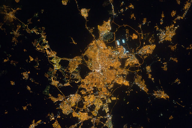
While the images taken by the Defense Meteorological Satellite Program has a scale of about 2.7 km per pixel, those obtained by astronauts aboard the International Space Station (ISS) have a better resolution depending of the lens used, reaching about 80 m/pixel.
We have used the original RAW image of Madrid (Spain) to study in full detail this image in his color channels and have proposed a sequence of observations to calibrate these nocturnal images to obtain useful scientific data on light pollution (PDF).
Links:
- Night images of cities from ISS
- Night images of Madrid from ISS and Madrid Bright Spots
- Mosaic of the Iberian Peninsula at Night
Literature:
- Differential photometry study of the European Light Emission to the space, Starlight conference (2007)
- Light pollution in Spain. An european perspective, SEA (2008)
- "ISS nocturnal images as a scientific tool against Light Pollution" UCM eprint (2011)
- Midiendo la contaminación del cielo desde el espacio, Colegio Oficial de Físicos (2011)
- "ISS nocturnal images as a scientific tool against Light Pollution: Flux calibration and colors" IAU 2012 communication
- "Using gvSIG to compute light pollution from night satellite images" (read in gvSIG Outreach)
- El uso de imagenes de satélite para combatir la contaminación lumínica, AstronomíA (2013)
- Atlas of astronaut photos of Earth at night, ASTRONOMY & GEOPHYSICS (2014)
- High-Resolution Imagery of Earth at Night: New Sources, Opportunities and Challenges, mdpi.com (2014)
- Light pollution from the ground, the air and the space, SEA (2014)
- Statistical modelling and satellite monitoring of upward light from public lighting, Lighting Research and Technology, (2015)
- Georreferenciación colaborativa de imágenes nocturnas tomadas desde la ISS para estudios de consumo energético y contaminación lumínica, Universitat de Girona. Servei de Sistemes d'Informació Geogràfica i Teledetecció (2015)
- Variación espacial, temporal y espectral de la contaminación lumínica: Metodología y resultados. (2015)
Images from the NASA repository maintained by the Image Science and Analysis Laboratory, NASA-Johnson Space Center. "The Gateway to Astronaut Photography of Earth."